 |
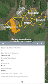
| A concept screen under development where GIS layers of information can be stacked and selectively displayed on the community web map. |
 |
| Meramat operates a drone to map GPS coordinates. |
 |
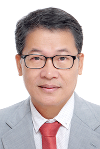
| Meramat Tajak |
AS Sarawak moves into the future with a digital economy, traditional longhouses and villages should brace for change and transformation by getting ready to adapt and jump on the global digital bandwagon.
Human rights activist Malcom X once said, “the future belongs to those who prepare for it” – and that’s exactly what rural Sarawak should be gearing up for.
Sarawak is staring at Industrial Revolution 4.0 (IR 4.0), and as 5G telecommunication beckons, there is no escaping the impact nor ramifications of big data and artificial intelligence applications. Rural Sarawak has to shift gear or be left behind.
Ancestral land ownership is largely undocumented as it has been dictated since time immemorial by oral tradition on a longhouse verandah or ruai but this should be consigned to history in time to come.
A resident of an Iban longhouse in Julau and his colleagues have taken up the challenge to bring the future to the doorsteps of the longhouses and villages, with digital community mapping, using their platform called Ottomap, through crowdsourcing.
Meramat Tajak believes the time to act is now as the fast evolving socioeconomic and physical landscape changes, engendered by the digital economy, could upend conventional lifestyles and practices but, at the same time, provide untold opportunities for rural Sarawak as well.
A US-trained instrument engineer with a double degree in computer and electrical engineering, Meramat had worked in the US for two years before joining Sarawak Shell Berhad where he stayed for 25 years (1991 to 2016).
He served in various positions, including for ICT, instrument engineering, artificial intelligence (artificial neural network), project management, contracting, and tendering.
In Shell, he had project experience in Digital Oilfield Initiatives, known locally as Computer Assisted Operation and Smart Field, as well as in Enhanced Oil Recovery Conceptual Engineering and Detail Design.
Together with his colleagues, comprising a Geographical Information System expert, a senior engineer, an economist, a banker, an auditor, and some associates, Meramat is envisaging the benefits of the digital era for Sarawak – from laying the foundation of big data to rural assets, points of interest, environmental concerns, transportation, logistics and agricultural activities, using the scalable technology of GIS as a foundation, starting with crowdsourcing land use data.
Incidentally, land ownership has become a nagging source of concern when oral tradition and physical boundaries are blurred with the passage of time.
Most native land in Sarawak are without titles, while boundaries between plots are often demarcated by perishable landmarks such as bamboo, stumps of hard wood (belian), tall trees (tapang), or even fruit trees like jackfruit.
“Memories of demarcation are passed on from one generation to the next and when the elders die, some of the memories will be lost,” Meramat said of the downside of such a sharing tradition.
Common occurrence
Due to the rural-urban drift, many younger generation natives, working in the towns and cities, are unable to visit their land heritage in the rural areas. In fact, land left idle by families from longhouses and villages is quite common all over Sarawak.
“Each family has a few parcels of native land that are left idle, and, most worryingly, undocumented except through oral history,” he noted.
With fading memories of land demarcation and passing of the present generation, the real danger can manifest itself in serious conflict over land issues in the native community when owners of adjoining parcels will fight tooth and nail to settle disputes over land demarcation in the Native Court.
“Fortunately, modern Geographical Information Systems (GIS) technology can help landowners to transcribe their oral knowledge of land demarcation between their adjoining parcels or plots into digital format so that the land can be seen on the Web, like Google Map,” Meramat added.
Together with like-minded friends, he set up a company – CDMI GIS PLT – and spent about a year researching and testing GIS for the broader purpose of community mapping.
This is a broader technical term which includes mapping of land parcels, land use, transportation routes, points of interest and other applications in rural and suburban areas not shown by Google Maps.
“In GIS technology, all this information is programmatically described as GIS layers like kek lapis of Sarawak,” he said, adding that GIS technology and future applications would boost Sarawak’s rural big data drive and digital economy if the people were willing to participate.
“What Google Maps provides for urban areas, we envisage providing for rural areas,” he assured.
According to Meramat, in a rural setting, Google Maps does not have information of your place on locations of clear running streams or creeks, best durian trees in the orchard, fresh local rice fields, highly regarded craftsmen and women and other useful data with which to evince economic activities, valuable assets and people’s way of life in the rural areas.
Attracting supply chain
CDMI GIS PLT founders have in mind to bring digital economy to both urban and rural areas to attract the global supply chain (markets, tourists and investors) to their land instead of going out to look for it.
There are roughly over 5,000 longhouses and villages in Sarawak with land heritage, amounting to about a million parcels or plots, based on the average of four plots per family and 50 families per longhouse or village. As they are not digitised into the big data platform, there is a huge reservoir of untapped opportunities to add value to the various assets for the benefit of the people.
However, it’s a massive undertaking and not economical if done by the government since the people know their territories best.
“It’s for this reason CDMI GIS PLT’s approach to digitising land parcels as the foundation for big data has been to let the end users do it themselves, “Meramat explained.
How to do it
CDMI GIS PLT has adopted and customised a free smartphone app called GeoODK, which runs on Android smartphones.
Land owners only need to download the app, make a few configurations and follow the instructions on using the app. Based on the system, the smartphone is built with Global Positioning System (GPS) technology to record GPS coordinates of land parcels.
The CDMI GIS PLT team understands very well that high accuracy data cannot be expected from smartphone location capabilities but the app provides enough information for the natives and their future generations to retain some tangible information on their parcels of land such as who are their neighbours and where are the plots situated.
When the recording of GPS coordinates is completed, the app will send the data to the CDMI GIS PLT server for processing and display on the CDMI website – Ottomap – within the aspired target of five days.
In digitising land demarcation information with the app, users will also be able to take three photos of the land and list any assets within the land boundary, including crops, fruit trees, wild honey, non-timber products, timber, cabins, or points of interest to provide comprehensive profiling of the property for any future use by the land owners such as direct selling of crops, fruits, and other products from the land to web consumers.
Meramat said individual landowners, NGOs, Aduns, and MPs, who supported the CDMI GIS initiative have been invited to join them in transcribing oral history of land heritage demarcation into digital format on the Internet, while the elders were still around to provide guidance.
CDMI GIS PLT has already been in touch with four technology-savvy Aduns from both sides and also held meeting with one of them who has expressed support for the company’s initiative and is willing to help start a pilot project, subject to concurrence of the constituencies involved.
CDMI GIS PLT welcomes collaboration with NGOs, which share the same objective of creating awareness and organising end-user training anywhere in Sarawak when there is clear indication of interest on the part of landowners or their children and relatives.
The aim is to make the system use-friendly and affordable. The first submission of one land parcel, regardless of size, will cost only RM50, inclusive of the RM15 fee to maintain the land parcel on the Internet for the first year.
Each subsequent year, landowners are required to pay an annual usage fee of RM15 per parcel. They can choose to discontinue their account for a certain period and reactivate it any time in the future.
Short training
For landowners in one whole longhouse who wish to learn GeoODK app to digitise their parcels of land and related assets, CDMI can organise a visit to conduct a short training at a pre-agreed cost and scope.
Those who have been trained will help others so that the training can be completed as soon as possible.
Members of the public who know how to use GPS app on their smartphones and are willing to provide GPS coordinates of the estimated 5,000 longhouses and kampungs in Sarawak, are welcome to send the coordinates to CDMI email address at ottomap@gmail.com.
“This is for showing off our longhouses or kampungs on the CDMI website (Ottomap),” Meramat said.
He noted that with much focus on land laws but less on making land economically vibrant and environmentally sustainable, using the community-built web map to convert memories of land demarcation into permanent digital records was a matter of urgency and not a lofty ideal.
By using GIS technology, GPS, and the Internet, he pointed out, it is possible to record the exact positions of anything on Earth, including land boundaries and related assets.
“When all this is done, the Sarawak rural community will be the first in the world to apply GIS as the foundation for big data. This is no exaggeration but well within the realm of possibility,” he enthused.


No comments:
Post a Comment